
File:EuropaNATOWP1959.png

Size of this preview: 582 × 599 pixels. Other resolutions: 233 × 240 pixels | 466 × 480 pixels | 746 × 768 pixels | 1,165 × 1,200 pixels.
Original file (1,165 × 1,200 pixels, file size: 353 KB, MIME type: image/png)
Summary
| Description |
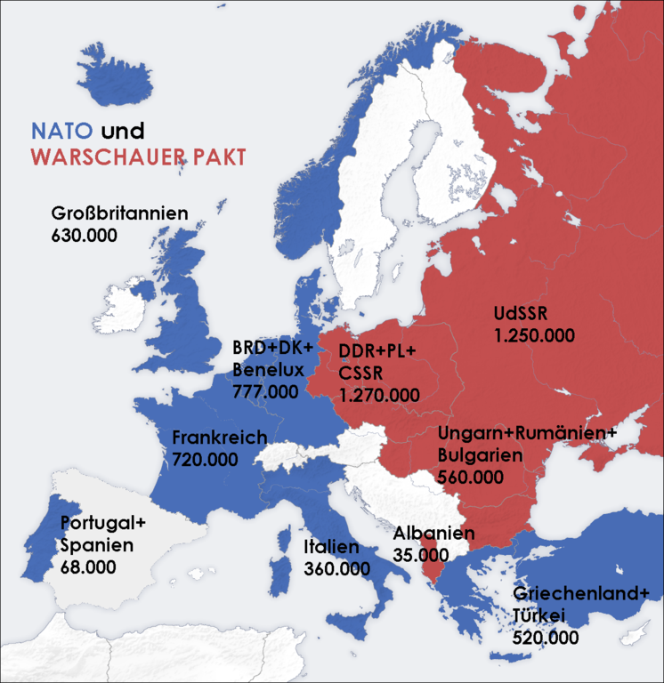
Deutsch: Truppenstärke der NATO-Mitgliedsstaaten in Europa und der Staaten des Warschauer Paktes 1959
Bei der Erstellung der Landkarte wurden die Generic Mapping Tools verwendet: http://gmt.soest.hawaii.edu/ Für das Relief - falls vorhanden - wurde(n) einer oder mehrere dieser externen Public Domain-Datensätze verwendet:
English: Troop strengths of NATO members in Europe, and of Warsaw Pact members, 1959 Map was created using Generic Mapping Tools. Data for the relief is from these public domain sources:
|
| Date |
6 November 2006 (original upload date) |
| Source | Karte basiert auf de:Bild:Cold war europe military alliances map.png von San Jose. Karte überarbeitet und Datenmaterial der de:NATO aus Fischer Weltalmanach eingefügt. |
| Author | wikifreund, Germany |

|
This map of europe image could be re-created using vector graphics as an SVG file. This has several advantages; see Commons:Media for cleanup for more information. If an SVG form of this image is available, please upload it and afterwards replace this template with
{{vector version available|new image name}}.
It is recommended to name the SVG file “EuropaNATOWP1959.svg”—then the template Vector version available (or Vva) does not need the new image name parameter. |
Licensing

|
Permission is granted to copy, distribute and/or modify this document under the terms of the GNU Free Documentation License, Version 1.2 or any later version published by the Free Software Foundation; with no Invariant Sections, no Front-Cover Texts, and no Back-Cover Texts. A copy of the license is included in the section entitled GNU Free Documentation License. |
| This file is licensed under the Creative Commons Attribution-Share Alike 3.0 Unported license. | ||
| ||
| This licensing tag was added to this file as part of the GFDL licensing update. |
Original upload log
The original description page was here. All following user names refer to de.wikipedia.
- 2006-11-06 21:00 Wikifreund 1165×1200×8 (361336 bytes) {{Information |Beschreibung=Truppenstärke der NATO-Mitgliedsstaaten in Europa und der Staaten des Warschauer Paktes 1959 |Quelle=NATO-Datenmaterial aus Fischer Weltalmanach |Datum=6. November 2006 |Genehmigung= |Andere Versionen= |Anmerkungen=Truppenstä
|}}}}}
File history
Click on a date/time to view the file as it appeared at that time.
| Date/Time | Thumbnail | Dimensions | User | Comment | |
|---|---|---|---|---|---|
| current | 14:20, 5 July 2008 | | 1,165 × 1,200 (353 KB) | Sanandros | {{Information |Description={{de|Truppenstärke der NATO-Mitgliedsstaaten in Europa und der Staaten des Warschauer Paktes 1959<br/> {| | Bei der Erstellung der Landkarte wurden die '''Generic Mapping Tools''' verwendet: http://gmt.soest.hawaii.edu/ Für d |
File usage
There are no pages that use this file.
Global file usage
The following other wikis use this file:
- Usage on ca.wikipedia.org
- Usage on de.wikipedia.org
- Usage on fr.wikipedia.org
- Usage on rm.wikipedia.org
- Usage on ru.wikipedia.org