
File:Welthunger-index 2009.svg

Size of this PNG preview of this SVG file: 800 × 353 pixels. Other resolutions: 320 × 141 pixels | 640 × 283 pixels | 1,024 × 452 pixels | 1,280 × 565 pixels | 2,560 × 1,130 pixels | 940 × 415 pixels.
Original file (SVG file, nominally 940 × 415 pixels, file size: 1.59 MB)
Summary
| Description |
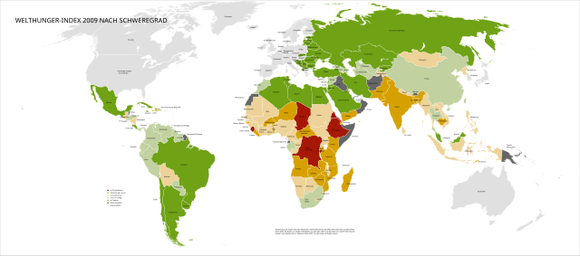
Deutsch: Die Karte bildet den von IFPRI und der Welthungerhilfe jährlich gemessenen Welthunger-Index 2009 nach Schweregrad ab. Dunkelgrün ausgefüllte Flächen bedeuten wenig Hunger, helgrün bedeutet mäßig Hunger, apricot bedeutet eine ernste Hungersituation, orange eine sehr ernste Hungersituation und rot eine gravierende Hungersituation. |
| Date | Data Summer 2009, world map December 2007 |
| Source | Data from File:Whi2009 karte.jpg and blank world svg from File:BlankMap-World6, compact.svg |
| Author | Data muehlhaus & moers Kommunikation, world map Canuckguy et al., combination by Palosirkka |
| Permission (Reusing this file) |
Data GFDL, world map public domain |
| Other versions |
 |
| SVG development | This vector image was created with Inkscape. |
Licensing

|
Permission is granted to copy, distribute and/or modify this document under the terms of the GNU Free Documentation License, Version 1.2 or any later version published by the Free Software Foundation; with no Invariant Sections, no Front-Cover Texts, and no Back-Cover Texts. A copy of the license is included in the section entitled GNU Free Documentation License. |
Embedded text

|
This SVG file contains embedded text that can be translated into your language, using any capable SVG editor, text editor or the SVG Translate tool. For more information see: About translating SVG files. |
File history
Click on a date/time to view the file as it appeared at that time.
| Date/Time | Thumbnail | Dimensions | User | Comment | |
|---|---|---|---|---|---|
| current | 11:43, 30 January 2018 | | 940 × 415 (1.59 MB) | Palosirkka | {{Information |Description={{de|Die Karte bildet den von IFPRI und der Welthungerhilfe jährlich gemessenen Welthunger-Index 2009 nach Schweregrad ab. Dunkelgrün ausgefüllte Flächen bedeuten wenig Hunger, helgrün bedeutet mäßig Hunger, apricot be... |
File usage
There are no pages that use this file.
Global file usage
The following other wikis use this file:
- Usage on eo.wikipedia.org
- Usage on he.wikipedia.org
- Usage on sv.wikipedia.org